Cycle Routes |
 |
Cycle Routes |
|
These pages are intended to help find the best routes for cycling in and around Elmbridge.
The routes described here have developed from ten years experience of cycling in Elmbridge, for rides with the children, journeys to the shops, and sometimes just as a pleasant way to get some fresh air and exercise. They aim to provide a network of routes for travelling by bicycle, based on the following criteria:
These routes are not ‘pleasure rides’ to arrive at with the bike on the back of a car, though many are a pleasure to ride on. They are the infrastructure for a local transport system, passing close to your home in Elmbridge, and allowing you use your cycle to get to where you want to go with the minimum of risk and, we hope, with some enjoyment.
That all sounds perfect on paper, but what about the reality? Well, many of the routes fully meet the ideal. They are regularly used for cycling, often by young (road-trained and accompanied) children. However to find a usable network from existing roads and tracks inevitably leads to some compromises. To fill gaps in the network, several stretches of road have been included which are far from ideal, but there is nothing better. I hope that others using this site will feed back their suggestions for variations or alternatives to these routes. I also hope that this site may help provide some ideas to the borough's transport planners, who are already working to improve our cycling infra-structure in Elmbridge.
How to use this page
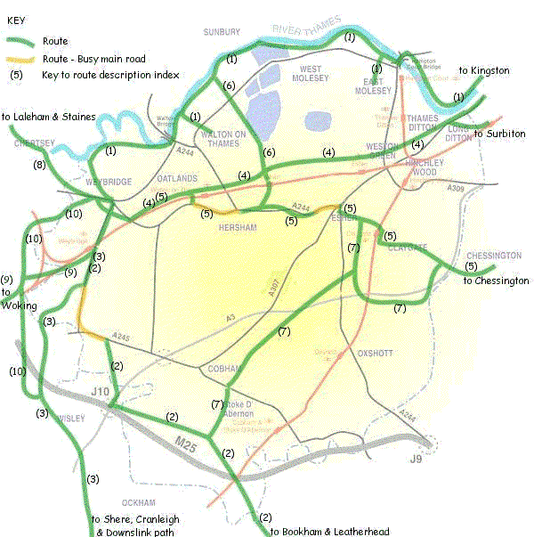
The routes shown on the following map indicate the approximate routes only. To find further details, use the number marked on the route and the table below the map to access the route description. This also gives links to other connecting routes.
How to use the route descriptions
The route descriptions provide an outline map and a written description sufficient to follow the route. Distances are given in kilometres (km) and miles (M) from the start of each headed sub-section. Where available, photographs are included to illustrate the route.
The maps are intended only as a guide, and are best used in conjunction with the appropriate map from the Ordnance Survey Landranger series, or similar. The text supplements the maps, and warns of anything particular to watch for, such as stretches of busy road. But beware; you may be using a normally quiet lane on the day of the local agricultural show, so follow the highway code at all times, and always assume that there’s a car about to come round the next corner.
Similarly, several sections are on little-used footpaths, with no right of way for cyclists, and it is the cyclist's decision whether he gets off and walks, or rides carefully giving way to pedestrians, but risking prosecution.
For no particular reason, the routes have generally been described from West to East, except where that would result in the description starting outside the borough. If this makes it appear that all routes start in Weybridge, then apologies to the rest of the borough!
Updated 29/10/03